 Welcome!


GPS Monitoring System / Cardio Access Key
 Title: GPS Monitoring System
 Awards: -
Release Date: 01-05-2016
1. Summary
For the lifeguard organization in Katwijk aan Zee (the "Katwijkse Reddingsbrigade" or "KRB") I created a system to monitor the positions of every active unit using the GPS data of the radio they are carrying with them. Together with Ronald Zwanenburg, Rene Plokker (hardware), Galit Rahim (operating system installation) and Kevin van Nieuwenhuizen (art) I developed an ASP.NET server and web application that visualizes the location of each active radio. I was responsible for all the software including the system architecture design.
After a while this software was also used for tracking detainees on leave. We won a prize with a Veiligheid & Innovation competition where we received money to do research how to use the Nymi Band (working with Bluetooth Low Energy) for access control and tracking in (juvenile) prison.
A few years later I decided on rewriting the whole application so the front-end would be written in Angular and the back-end use Entity Framework instead of stored procedures. I also hosted everything in Azure and made the project full CI / CD, with the pipelines in Azure DevOps.
2. System
The system consists of three major components, namely the Radio Communication Application or Android application, the ASP.NET Server and the Web Application.
Every active radio is constantly requested to send its GPS location (amongst other information) by the Radio Communication Application. All communication is done over a COM port on one of the radios. After receiving the GPS data, the Radio Communication Application extracts the GPS data and sends it to the server.
In case of tracking detainees the radios are replaced by an Android app that constantly checks if the Nymi band is activated and near the phone and send this information, combined with its GPS info, to the server.
The ASP.NET server is responsible for recieving the GPS info, storing it in a database and, when requested, send over GPS data of a device to a client's browser via a SSL protected web API.
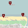
The web application shows a map using Open Layers. Point of Interests and icons for each active device are drawn on the map. The user can pan, zoom, and rotate the map as well as use a dropdown menu to focus on a certain devices or Point of Interests.
3. Background Information
For the Lifeguard organization the Katwijkse Reddingsbrigade or KRB (which I am part of myself) I developed this system as a hobby project. Ronald Zwanenburg and Galit Rahim (also part of the KRB) approached me with this idea. As I have done a similar thing at work (Science [&] Technology: Vision B.V.), I already had a lot of experience with the necessary technologies.
The advantages of this system are numerous. For example, if an accident happens somewhere on the beach one can easily see where this accident is and send the nearest unit without any time loss. Before this system went live, they had to ask the position of every active unit individually over the radio, which takes a lot of time. With some accidents time is critical and every second counts. This system is thus very useful in such cases. It saves time and avoids unnecessary radio communication.
Obviously, knowing where detainees on leave are is a requirement for prisons. Additionally, the history feature can help the supervisors to check where the detainees have been.
Media: Images
Go back
Show: All Projects
Show: Game Projects
Show: Software Projects